The Pyramid walk: Girraween National Park guide

Published
Last updated
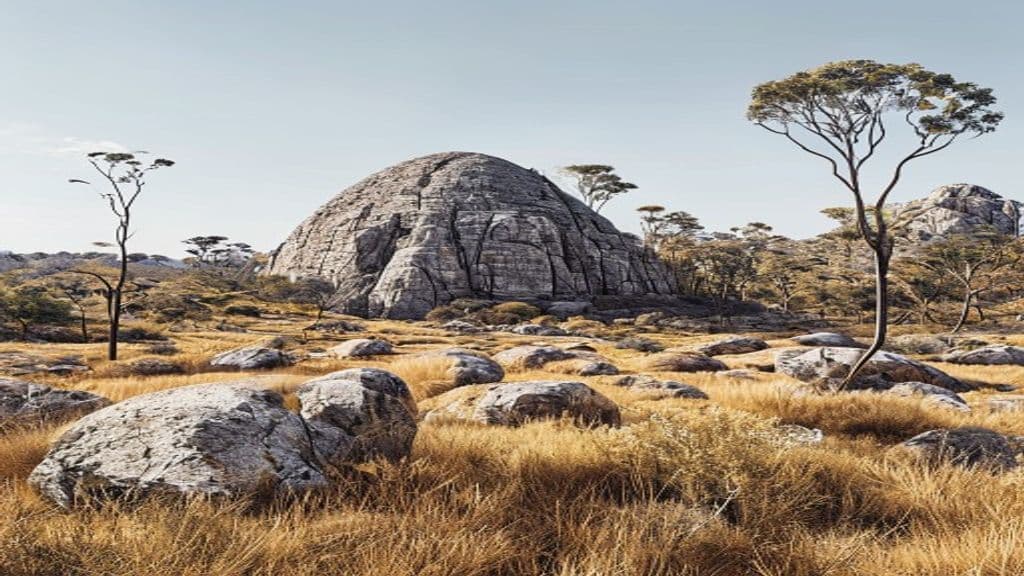
The Pyramid walk is one of Queensland's most distinctive short summit hikes. Girraween National Park swaps rainforest and coastline for granite slabs, balancing boulders, and open woodland, so the scenery feels very different from many of the state's better-known walks. About 30 minutes south of Stanthorpe, it is a memorable Granite Belt half-day outing with huge weathered boulders, the famous Balancing Rock near the top, and wide views across the park and toward the Second Pyramid.
The route is only about 3.6 km return, but it is not an easy lookout stroll. The granite terrain and the final climb across steep exposed granite are the crux, especially once you reach the exposed upper slabs. In dry weather, fit walkers who are comfortable on rock get a memorable outing with huge views across the Granite Belt.
Quick route overview
- Distance: about 3.6 km return
- Time: around 2 hours, allow longer for breaks, summit photos, or if you wait for others on the upper rock
- Difficulty: hard (Grade 4)
- Terrain: formed bush track, rock steps, granite slabs, uneven stone, and a steep exposed rock climb near the summit
What to expect on the walk
From the Bald Rock Creek day-use area, the signed northern walks track heads past Granite Arch and begins climbing through open eucalypt forest. Early on, the walking is comparatively straightforward, with rocky outcrops and grassy flats breaking up the ascent. It is easy to think this will be a simple stroll, but the gradient builds steadily as you move closer to the base of The Pyramid.
The middle section is a good warm-up rather than a major obstacle. You pass through classic Girraween scenery with smooth granite outcrops, dry bushland, and scattered boulders that make the park feel very different from Queensland's rainforest and coastal tracks.
The character changes once you reach the base of the main granite dome. From here, the route becomes much more exposed and the final section is where many walkers need to slow down, focus on their footing, and make an honest decision about comfort levels. There are no ropes or fixed aids on the upper rock. The route leaves the feeling of a standard footpath and moves onto steep exposed granite where good grip, balance, and calm footing matter. In dry conditions, confident walkers with decent fitness will often find it exciting rather than technical, but it is not the place to test yourself for the first time on wet rock or when you are uneasy with heights.
If conditions are dry and you are confident on steep granite, the summit reward is excellent. Balancing Rock is the signature feature, and the views stretch across Girraween's granite domes, forested ridges, and broad Granite Belt country. It is a short walk on paper, but it still feels like a proper summit outing.
Highlights
- A very different Queensland landscape, with granite country instead of rainforest or coast
- Balancing Rock and wide views toward the Second Pyramid and surrounding ridges
- Short overall distance with a strong sense of challenge and reward
- Distinctive granite slabs, tors, and open bush scenery unlike wetter Queensland parks
- Good birdlife, rock formations, and spring wildflower colour around the park
- A good option for walkers who want a strong half-day track rather than an all-day hike
Safety and conditions
Check official updates before you go:
- QPWS The Pyramid
- QPWS Girraween National Park
- QPWS visiting safely in Girraween
- QPWS Girraween National Park maps and resources
Important safety points:
- Do not attempt the steep granite upper section in rain, soon after rain, after heavy dew, or when storms are building. Smooth rock becomes much more slippery than it looks.
- Carry water, even though the walk is short. The exposed granite and open woodland can feel hot quickly, and the exposed rock still reflects heat.
- There are steep drop-offs near the summit area. Supervise children closely and do not pressure anyone to continue if they are uncomfortable.
- Start earlier than you think you need to on warm days, and leave time to descend carefully rather than rushing the return. Many walkers find the upper granite feels more awkward on the way down than on the climb up.
- Stick to the marked route and avoid shortcutting across fragile granite vegetation.
- If anyone in your group is uncomfortable on exposed rock, turn around before the final slabs rather than pushing on.
- Keep back from edges near the summit area and around large rock formations.
Practical tips for walkers
- Arrive early on weekends, school holidays, and spring wildflower periods when Girraween is popular, so you can park easily and walk before the upper rock heats up.
- Wear shoes with reliable grip. This matters more here than on many short tracks, and smooth-soled casual footwear is a poor fit.
- If this is your first Girraween visit, pair The Pyramid with an easier walk such as Granite Arch or Wyberba Walk rather than trying to add too much distance after the summit.
- Use Stanthorpe or Ballandean as your base. Cooler months often give the most comfortable walking conditions, but early starts still help with light, parking, and weather.
- For broader visitor planning, Southern Downs and Granite Belt's Girraween National Park guide adds useful regional context.
- For a walk-focused regional overview, Southern Downs and Granite Belt's Pyramid walk guide adds useful local context.
- If the upper granite does not feel right on the day, turn around before the summit push. You will still get a worthwhile walk and a safer outing.
- If you enjoy short Queensland climbs with a clear summit objective, the Mount Ngungun Summit track is another worthwhile walk in a very different landscape.
The Pyramid walk is one of the best short summit hikes in southern Queensland, but it earns that reputation because the upper climb demands respect. Treat it as a short, strenuous walk rather than an easy lookout stroll, pick a dry day, save enough energy for the careful descent, and it can be one of the standout tracks in the Granite Belt.