Pyramid walking track: Porcupine Gorge National Park guide

Porcupine Gorge National Park, Outback Queensland, Australia
Published
Last updated
The Pyramid walking track descends from the rim of Porcupine Gorge to Porcupine Creek, about 74 km north of Hughenden. The short distance is deceptive: walkers lose about 120 m on the way into the gorge and regain it on the return climb.
The 2.4 km return track leads through layered sandstone country to the gorge floor and a view of the Pyramid, an isolated sandstone formation shaped by erosion. QPWS grades the walk 4, so it suits fit walkers comfortable with steep steps, uneven ground and exposed outback conditions.
Quick route overview
- Distance: 2.4 km return
- Time: allow 1 hour 30 minutes
- Grade: Grade 4 walking track
- Route type: out and back
- Terrain: steep formed track, steps, loose and uneven surfaces, then exposed rock beside Porcupine Creek
- Start: Pyramid camping and day-use area, Porcupine Gorge National Park
- Access: conventional vehicles can reach the day-use area; check local road conditions before leaving Hughenden
What to expect
The track starts near the Pyramid camping area and descends through open woodland into the gorge. Steps and switchbacks manage the steepest parts, but the surface remains rough. The return follows the same route, with the sustained climb saved for the end.
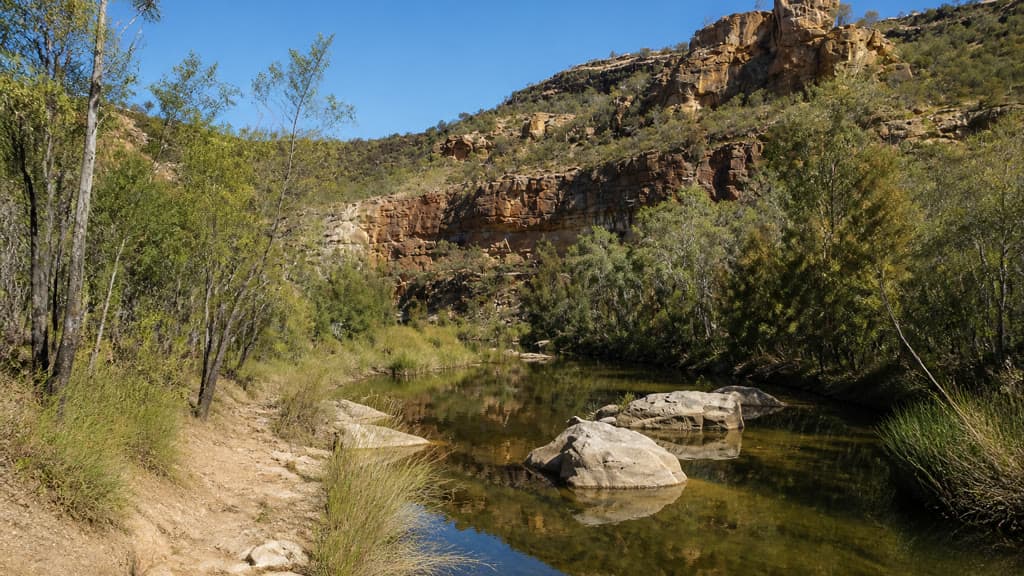
At the bottom, a broad sandstone platform runs beside Porcupine Creek. Water levels and flow vary with recent rain. The surrounding walls expose bands of differently coloured sandstone, and the Pyramid rises separately from the gorge wall. Keep to the marked route and do not extend the walk along the creek unless you have the skills and preparation for remote bushwalking.
Porcupine Gorge is on Yirendali Country. The QPWS Porcupine Gorge National Park page includes the park's welcome from the Yirendali people and current visitor notices.
Safety and conditions
- Check the forecast and the QPWS park page before travelling. Porcupine Creek can rise quickly during and after heavy rain, so do not enter the gorge when flooding is possible.
- Start early in warmer months. Average maximum temperatures from October to February often exceed 35 degrees Celsius, and much of the track and gorge floor is exposed.
- Carry all the drinking water you need. There is no treated water at the camping or day-use area, and water collected from the creek must be treated before drinking.
- Wear sturdy footwear for the steps, loose surfaces and smooth creek rock. Take care around cliff edges, steep slopes and rock faces.
- Mobile reception is very unreliable. Save directions and park information offline, and tell someone your route and expected return time.
- Dogs and other domestic animals are not permitted in Porcupine Gorge National Park.
Practical tips
The gorge lookout is about 60 km north of Hughenden on the Kennedy Developmental Road. Continue roughly 11 km farther north to the signed turn-off for the Pyramid camping and day-use area. The access is suitable for conventional vehicles, but road conditions can change after rain. Watch for cattle, wildlife and road trains.
The day-use area has non-flush toilets and picnic tables but no drinking water or rubbish bins. Take food, water and fuel from Hughenden, and carry all rubbish out.
Camping beside the track requires a permit and booking. The QPWS Pyramid camping area page has booking details and fire conditions. The Flinders Shire visitor guide is useful for road information and local planning.
For the official distance, time and track information, see QPWS things to do in Porcupine Gorge. For a much longer sandstone gorge walk in inland Queensland, see the Carnarvon Gorge Main Track guide.