Cape Hauy walk: Tasman National Park guide

Tasman National Park, Tasman Peninsula, Tasmania, Australia
Published
Last updated
The Cape Hauy track is a return walk from Fortescue Bay to the dolerite cliffs at Cape Hauy on the Tasman Peninsula, about 90 minutes' drive south-east of Hobart. Parks and Wildlife Service Tasmania grades the track 3 and lists it at 9.4 km return, with about 4 hours walking. It suits walkers with some bushwalking fitness who are steady on steep stone steps and unprotected cliff edges, rather than young children or anyone unsure near drops.
The Tasman Peninsula is officially dual-named Turrakana / Tasman Peninsula, and the area is country of the Pydairrerme people of the Paredarerme language group. The Parks and Wildlife Service Cape Hauy page carries the official track notes and current alerts.
Quick route overview
- Distance: 9.4 km return
- Time: allow about 4 hours return
- Grade: Grade 3
- Route type: return (there and back)
- Terrain: formed track through woodland and heath, then steep stone steps to an exposed cliff-top lookout
- Start: Fortescue Bay day-use car park, Tasman National Park
- Access: sealed roads to Eaglehawk Neck, then 12 km of unsealed C344 (Fortescue Bay Road) suitable for 2WD vehicles
What to expect
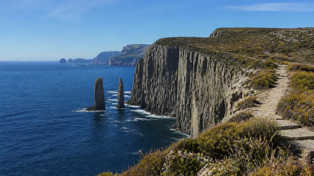
The track leaves the Fortescue Bay day-use area and skirts the bay before climbing inland through woodland and heath. Wildflowers are thick in spring and early summer. The forest then opens onto the undulating crest of the cape, and the surface switches to stone steps that drop into a saddle and climb again toward the headland.
The final approach runs along exposed cliff tops to a viewing platform at the tip of the cape. Below, vertical dolerite columns drop straight into the sea, with the free-standing Totem Pole and Candlestick sea stacks the best-known features. On a clear day the view runs north past the Hippolyte Rocks toward Maria Island and south along the cliffs toward Cape Pillar. Seabirds, eagles and, in season, whales are often seen from the cliff tops, but the view is never guaranteed in cloud or wind.
The same route returns to Fortescue Bay. The descent is straightforward, but the steps are hard on tired knees, and the rock is slippery after rain.
Safety and conditions
- Check the Parks Tasmania Cape Hauy page and the weather before you leave. Tasman Peninsula weather can change at any time of year.
- The track has unprotected cliff edges. Supervise children closely, stay back from edges, and do not climb onto rocks for a photo.
- Wear sturdy footwear with grip. The stone steps are slippery when wet, and there are well over a thousand of them.
- The headland is exposed. Carry a warm layer, a rain jacket, sun protection and drinking water, even on a still day at the car park.
- Mobile reception is unreliable on the cape. Save the park page and a map offline before you go, and tell someone your plan.
- The track closes each autumn for maintenance and fuel-reduction burns. Planned dates are 5 to 18 April 2027, 24 April to 7 May 2028, and 9 to 22 April 2029. There is no Cape Hauy closure in 2026; check the park page for any short-notice alerts.
- Dogs and other pets are not permitted in Tasman National Park, except assistance dogs that meet Parks Tasmania's entry requirements.
- Tasman National Park is a fuel-stove-only area. Campfires are not permitted outside the designated fireplaces in the Fortescue Bay campground.
Practical tips
A valid Tasmania Parks Pass is required for every vehicle and must be displayed. Buy one ahead at passes.parks.tas.gov.au or at the Parks Pass machine in the Fortescue Bay day-use car park (card only). See the Parks Tasmania passes page for current rates and the Holiday and Annual pass options.
From Hobart, drive to Sorell on the A3, then follow the A9 (Arthur Highway) toward Port Arthur. To reach Fortescue Bay, continue past Eaglehawk Neck on the A9 to the junction with the C344 (Fortescue Bay Road), then drive 12 km on an unsealed road that suits 2WD vehicles. Keep left on blind corners and watch for delivery trucks, tour buses and wildlife, particularly around dawn and dusk.
The day-use car park has toilets, picnic tables and gas barbecues, but there is no drinking water on the track. Tank water at the campground should be boiled for three minutes before drinking. The nearest shop is at Nubeena, about 45 minutes' drive away.
Camping at Fortescue Bay is split between the Banksia and Mill Creek campgrounds. Bookings are required from 1 October to 30 April and open six months ahead; from 1 May to 30 September sites are first-in, first-served. See the Fortescue Bay camping page for fees and booking details.
The walk is most comfortable from late spring to early autumn, when days are longer and the steps are drier. Winter brings short days, cold wind and slippery rock, and the exposed cape is no place to be in a strong southerly. Start early in peak periods, as the day-use car park fills through the middle of the day.
For other Tasman Peninsula walking, the Three Capes Track is the multi-day walk that shares this route, and the Waterfall Bay track runs north toward Devils Kitchen. The Hobart Walking Club runs regular trips on the Tasman Peninsula if you want company or local knowledge.
For another short, steep coastal walk with a cliff-top finish, the Wineglass Bay Lookout walk on the east coast is a similar half-day proposition, and the Mount Oberon summit walk in Wilsons Promontory is a longer coastal summit with wide water views.