Wineglass Bay Lookout walk: Freycinet National Park guide

Freycinet National Park, East Coast Tasmania, Australia
Published
Last updated
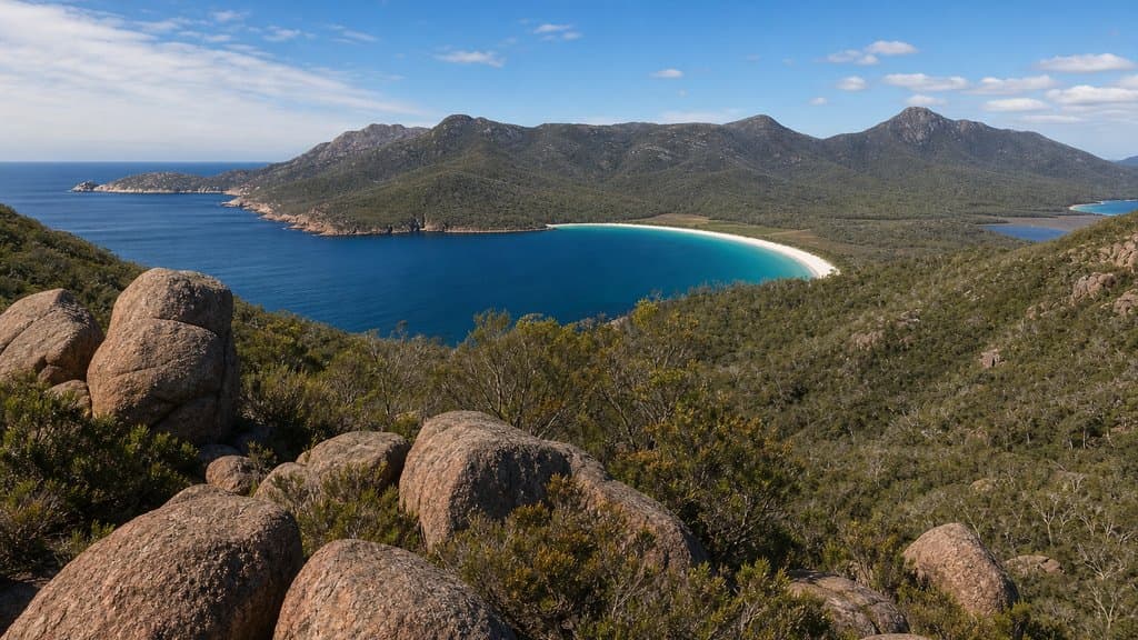
The Wineglass Bay Lookout is the short, steep climb most visitors to Freycinet National Park come for. It runs from the Walking Tracks Car Park up to a granite saddle between Mount Amos and Mount Mayson, where platforms look straight down onto the crescent of white sand and turquoise water that makes the bay famous. Parks Tasmania grades the track 3 and lists it as 2.6 km return, so it suits walkers with reasonable fitness who are steady on steps and loose gravel rather than anyone with restricted mobility or serious health issues.
Freycinet National Park is on the east coast of Tasmania, about 2.5 to 3 hours' drive from either Hobart or Launceston. Parks Tasmania notes the park lies within the territory of the Oyster Bay nation, and the Freycinet Peninsula was part of the country of the Toorernomairremener band. The Parks Tasmania Wineglass Bay Lookout page carries the official track notes and current alerts.
Quick route overview
- Distance: 2.6 km return (about 1.3 km each way)
- Time: 1 to 1.5 hours return
- Grade: Grade 3
- Route type: return to the saddle lookout
- Terrain: steep formed track, many steps, granite boulders and loose gravel through coastal woodland
- Start: Walking Tracks Car Park, end of Freycinet Drive, Freycinet National Park
- Access: sealed roads; conventional vehicles fine
What to expect
The track climbs from the car park through coastal woodland and past large granite boulders. It is a steady uphill walk on a formed track with many steps, and the surface is loose granite and gravel rather than a boardwalk. Resting seats are spaced along the climb, which is the main effort of the day.
Near the top the forest opens onto a granite saddle with viewing platforms. From there the bay curves below between the pink-orange headlands of the Hazards, with Mount Graham rising beyond the sand. Whales and dolphins are sometimes seen from the platforms, but the view itself is the draw and is never guaranteed in cloud or wind.
The same route returns to the car park. The descent is straightforward, but the granite and steps are slippery after rain. Do not extend the walk down to Wineglass Bay beach unless you have planned for the long stair descent and the harder climb back up, or booked the longer Hazards Circuit or Freycinet Peninsula Circuit.
Safety and conditions
- Check the Parks Tasmania Freycinet National Park page and the weather before you leave. Conditions in Tasmania can change at any time of year.
- The lookout platforms sit on hazardous cliffs. Stay behind the barriers, keep children close, and do not climb onto rocks for a photo.
- Wear sturdy footwear with grip. Freycinet tracks are often steep granite and loose gravel, and the surface is slippery when wet.
- Carry water, sun protection and a warm layer. The climb is exposed in places and the saddle can be windy and cool even when the car park is warm.
- Mobile reception is unreliable on the track. Save the park page and map offline before you go, and tell someone your plan.
- Tasmanian weather can turn cold and wet quickly. Even for a short walk, carry a rain jacket, a warm hat and a small first aid kit.
- Dogs and other pets are not permitted in Freycinet National Park. The park is fuel-stove only, with no open fires.
Practical tips
A valid Tasmania Parks Pass is required for every vehicle and must be displayed. Buy one ahead at passes.parks.tas.gov.au or at the Freycinet Visitor Centre near the park entrance.
From the Tasman Highway (A3), turn onto Coles Bay Road (C302) about 12 km south of Bicheno, then drive through Coles Bay township to the end of the sealed Freycinet Drive. The road is sealed and suitable for conventional vehicles. The Walking Tracks Car Park has toilets and a water tap but no other facilities, and there are no facilities on the climb. Refill water there before you start.
The car park fills early during the December to February school holidays and at Easter. Arrive early or have a plan B such as the Cape Tourville walk (Grade 1, 600 m) or Friendly Beaches while you wait, rather than parking on the roadside.
For current alerts and closures across Tasmania's parks, see the Parks Tasmania alerts page. For other Freycinet walks, the Mount Amos track (Grade 4, 3.6 km return) is a separate exposed granite scramble to a higher summit, and the Hazards Circuit (11 km, Grade 4) loops the saddle to Wineglass Bay beach and Hazards Beach. The Hobart Walking Club runs regular trips on the east coast if you want company or local knowledge.
For another short coastal climb with a steep finish, the Mount Coolum summit walk on the Sunshine Coast is a similar half-day proposition, and the Mount Oberon summit walk in Wilsons Promontory is a longer coastal summit with wide water views.