Castle Mountain walk: Cania Gorge National Park guide

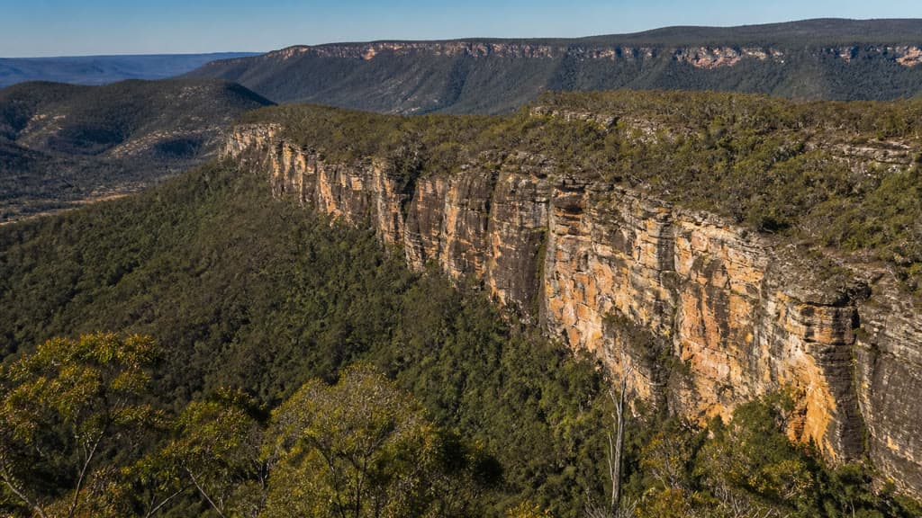
Cania Gorge National Park, Central Queensland, Australia
Published
Last updated
The Castle Mountain walk is the longest marked day walk in Cania Gorge National Park, north of Monto. Its 22 km return distance, long fire-trail section and isolated lookouts make it a full-day route for experienced bushwalkers rather than an extension to the park's short cave walks.
The track starts at Three Moon picnic area, climbs to Gorge lookout, then crosses open woodland above the sandstone gorge to Castle Mountain lookout. QPWS grades it 4 and advises walkers to be ready for rough conditions, navigation and unreliable phone reception.
Quick route overview
- Distance: 22 km return
- Time: allow 7 to 8 hours
- Grade: Grade 4
- Route type: out and back
- Terrain: formed walking track, a steep 200 m climb and about 10 km of fire trail each way after Gorge lookout; natural creek crossings and overgrown or obstructed sections are possible
- Start: Three Moon picnic area, Cania Gorge National Park
- Facilities at the start: car park, toilets, sheltered tables, barbecues and tank water that must be treated before drinking; no bins
What to expect
From Three Moon picnic area, follow the Bloodwood Cave track for 800 m to the signed Castle Mountain turn-off. The next 200 m climbs steeply to Gorge lookout. This early section gains the escarpment quickly and gives the first view down the gorge.
Beyond Gorge lookout, the route changes character. A fire trail winds for about 10 km through open eucalypt woodland to Castle Mountain lookout. The sandstone cliffs and darker dry rainforest below contrast with the drier woodland above the gorge. The destination gives a wider view across Cania Gorge and the country around Lake Cania.
Return by the same route. Most of the distance comes after the first lookout, so reaching Gorge lookout is not a useful measure of progress for the whole walk. Keep enough time, water and energy for the long return to Three Moon picnic area.
Safety and conditions
Read the QPWS Cania Gorge walking information, park map and current notices on the Cania Gorge National Park page before leaving.
- QPWS recommends this walk for experienced bushwalkers with navigation skills, first-aid self-reliance and the ability to manage weather hazards.
- The track can be extensively overgrown. Fallen trees and rock falls may obstruct the route, so carry the official map and a reliable offline navigation method.
- Natural creek crossings are part of the walk. Do not cross flooded or fast-flowing water.
- Gorge and Castle Mountain lookouts have unfenced cliff edges. Stay on the track and well back from edges, which can be closer than they appear.
- Phone reception is unreliable. Leave your route and expected return time with a responsible person and consider carrying a personal locator beacon.
- This is a hot, exposed full-day walk in warm conditions. Start early, check the forecast and carry enough drinking water rather than relying on the picnic-area tank.
- Dogs and other domestic animals are not permitted. Fires and camping are not allowed in Cania Gorge National Park.
Practical tips
- From Monto, drive about 12 km north on the Burnett Highway, turn onto Cania Road and continue about 14 km through Moonford to the gorge. North Burnett Regional Council advises that the road is sealed.
- Park at Three Moon picnic area and confirm the Castle Mountain route on the information display before setting out.
- Tank water at the picnic area must be boiled or chemically treated. Pack out all rubbish because there are no bins.
- There is no camping in the national park. Commercial caravan and camping grounds operate nearby if you need an early start.
- The North Burnett Regional Council national parks guide is useful for road and picnic-area details.
For another long Central Queensland sandstone walk, see the Carnarvon Gorge Main Track. The Bluff Point circuit is a much shorter Grade 3 option near the coast.