Mount Kosciuszko Summit walk: Charlotte Pass guide

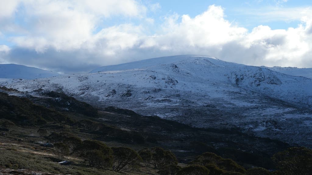
Kosciuszko National Park, Snowy Mountains, New South Wales, Australia
Published
Last updated
The Mount Kosciuszko Summit walk is the classic summer route to the top of Australia's highest mountain, an 18.6 km return track from Charlotte Pass in Kosciuszko National Park. NSW National Parks grades the walk 3 and suggests 6 to 8 hours, following the old summit road past the Snowy River, Seamans Hut and Rawson Pass to the 2228 m summit. It suits reasonably fit walkers who can handle a full day at altitude in weather that can change quickly, rather than anyone after a short stroll or a winter snow walk.
Kosciuszko National Park is on the traditional Country of the Monaro Ngarigo, Wolgalu, Wiradjuri and Ngunnawal peoples, and the high country was a summer gathering place for many Aboriginal groups travelling there for ceremony and trade. The NSW NPWS Mount Kosciuszko Summit walk page carries the official track notes and current alerts.
Quick route overview
- Distance: 18.6 km return
- Time: allow 6 to 8 hours
- Grade: Grade 3
- Route type: return (out and back along the old summit road)
- Summit: 2228 m, the highest point in Australia
- Terrain: formed track along an old road, occasional steps, short steep sections
- Start: Charlotte Pass, end of Kosciuszko Road, Kosciuszko National Park
- Access: sealed Kosciuszko Road from Jindabyne through Perisher to Charlotte Pass, about 40 km and 30 minutes; the road past Perisher closes in winter
What to expect
The track leaves the turning circle at the end of Kosciuszko Road and descends through snow gums to the Snowy River, about 4.5 km in. The river is crossed on stepping stones, and the crossing is not safe when water covers them. Beyond the river the track climbs steadily past snow gums, heath and herb fields to Seamans Hut at 5.9 km. The stone hut was built in 1929 as a memorial to skiers Laurie Seaman and Evan Hayes and is a useful shelter in poor weather.
From Seamans Hut the track continues to Rawson Pass at 7.6 km, where there are toilets and bike stands and views over Lake Cootapatamba, one of Australia's highest lakes. The final stretch from Rawson Pass to the summit is foot traffic only - bikes stop here - climbing about 1.4 km to the 2228 m cairn. On a clear day the view runs across the Main Range of the Snowy Mountains and toward the Victorian High Country. The same track returns to Charlotte Pass.
Wildflowers are at their best in early summer, with snow daisies, marsh marigolds, mountain roses and buttercups through the herb fields. The country above the tree line is open and exposed, with weathered snow gums giving way to low shrubs and grasses near the top.
Safety and conditions
- Check the NPWS alerts page and the Bureau of Meteorology alpine forecast before you leave. Alpine weather changes fast and the track is exposed for most of its length.
- The walk is snowbound from June to the October long weekend. NPWS advises against walking it in winter; there are no snow poles marking the route. Private vehicle access to Charlotte Pass is closed over the same period. Plan it for late spring to autumn.
- Carry warm and waterproof layers even on a fine day. Conditions at the summit can be cold, windy and foggy while the valley is calm.
- Bring drinking water, snacks, sun protection and sturdy footwear. NPWS lists a hat, sunscreen, topographic map, GPS and compass as standard alpine kit.
- Mobile reception is limited. Download the Emergency Plus app and a map before you go, and tell someone your plan. NPWS recommends lodging a trip intention form.
- The Snowy River crossing is dangerous when water covers the stepping stones. Wait for the flow to drop or turn back rather than risk it.
- Pets are not permitted in NSW national parks, except certified assistance animals.
- No wood or solid fuel fires are allowed in the alpine area. Bring a gas or fuel stove if you plan to cook.
- Recreational drone use is prohibited in this part of the park.
Practical tips
Park entry fees apply on Kosciuszko Road and Alpine Way: $17 per vehicle per day outside winter, and $29 per vehicle per day over the winter surcharge period (June to the October long weekend). Day passes, multi-day passes and annual All Parks Passes are available from NPWS visitor centres, vehicle entry stations and the Park'nPay app. Outside winter the road to Charlotte Pass is open, but check conditions before driving as snow and ice can linger into spring.
In winter, all 2WD vehicles must carry wheel chains on Kosciuszko Road, Guthega Road and the Alpine Way between Thredbo and Tom Groggin, and chains are recommended for 4WD and AWD vehicles in extreme weather. The road between Perisher and Charlotte Pass closes for the season.
Parking near the trackhead on Kosciuszko Road is limited and fills on weekends. Bus parking is available. The nearest shops, fuel and the Snowy Region Visitor Centre are at Jindabyne, about 40 km down the road.
The walk is most reliable from December to April, when the snow has cleared and the wildflowers are out. Start early to finish in daylight, and be ready to turn back if the weather closes in. The Thredbo to Mount Kosciuszko walk (13 km return, 4 to 5 hours) is a shorter, chairlift-assisted alternative to the same summit if a full day on the old road is more than you want.
For other Australian summit walks, the Bluff Knoll summit walk in Western Australia is a steeper climb to a higher-contrast peak, and the Mount Oberon summit walk in Victoria pairs a summit climb with coastal views. The Canberra Bushwalking Club runs regular trips across the Snowy Mountains and the ACT if you want company or local knowledge on the high country.